Contact KSN.org


Finding Fossils Pages
Cori's Fossil Map
Brownie's Beach
Flag Ponds
Calvert Cliffs State Park
Purse State Park
 Flag Ponds is a Calvert County park. It's on Route 2/4, just a mile or two north of
Calvert Cliffs State Park. Although it's not marked on many maps,
there are signs on 2/4; you can't miss it. Check out their
web site for more details.
Flag Ponds is a Calvert County park. It's on Route 2/4, just a mile or two north of
Calvert Cliffs State Park. Although it's not marked on many maps,
there are signs on 2/4; you can't miss it. Check out their
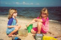
web site for more details.We have had great luck here just watching where the waves come in. Once your eyes are trained, you should be able to see the little treasures as they wash up; each wave brings up something new. And there's a lot more beach to cover than at the other public areas along the cliffs. We still haven't explored the ponds themselves, but they look interesting. Both the Choptank and St. Mary's formations are exposed here, meaning that the deposits are in the 8-18 million year old range.
Find more fossil sites on Cori's Fossil Map.